Friday, March 15, 2013

Data Gathering for Sand Mine Suitability

Intro to Data Gathering for the Project


In the previous post, the importance and potential risks of sand frac mining were discussed, as well as their ability to be analyzed in great detail with GIS software. To gain project-based experience that was relevant to this current issue, we were tasked to create the suitability and risk model for frac sand mining in Wisconsin. The first step in the process is to gather the necessary data. To understand the true impact of mining on the study area, a wide variety of base data was required, showing every type of feature that could be relevant to sand fracking. Because of the different types of data required for this project, multiple sources needed to be accessed in order to properly created the model. Data was acquired through multiple government sources, such as the Department of Natural Resources or the United States Geological Survey. The collection of base layers, while retrieved from different sources, were interoperable, and were able to be easily imported into ArcGIS, saving a considerable amount of time that would be otherwise spent normalizing and converting the files to be read together.

Data Gathering

When building a suitability and risk model to analyze the impact of frac sand mining, a number of base layers were required. The first step was to create a geodatabase to efficiently store the files that were to be downloaded, and ensure that everything was in the same projection. A specific projection provides the best results, so NAD83 UTM 15N was selected, giving the data the best possible representation. Next, a railroads shapefile was required for future network analysis of the impact of road degradation. To do this, the file from the National Atlas was downloaded. To analyze the potential issues with contamination of wetlands, the National Wetlands Inventory was consulted, with data downloaded specifically for Trempealeau County, which is where a large number of the sand mines are located. Land cover and elevation for the study area was obtained through the USGS National Map Viewer, which provided DEM raster files that required mosaicking them together to get a uniform image to be used for the model. Cropland data was provided by the United States Department of Agriculture Geospatial Data Gateway, and soil data was accessed through the Natural Resource Conservation Service's SSURGO service. Taken collectively, soil, cropland, railroad, wetland, land cover, and elevation data will provide the important first steps in the analysis of the impact of sand frac mining in the state of Wisconsin.

Geocoding

In order to conduct a proper analysis of the sand frac mines, the current location of the mines needed to be recorded obtained. Initially, the Trempealeau County land records division website was consulted for mine locations in that particular county. More data was required to make an accurate model, however, so data for the entire state was necessary. An Excel table was obtained through Wisconsin Watch to complete this task. The next step was to geocode the location of the mines from the two sources. Geocoding is the process of matching addresses found in a table to locations on a map, with a point being plotted in each spot where a sand mine is located. The table from Wisconsin Watch had an address field in it, which would be used in placement of the mines. However, that field was not normalized, something that is absolutely essential in the geocoding process. In order for the point to be plotted in the correct place, all elements of an address (number, street name, city, state, zip code) needed to be in the same format. Unfortunately, the table had several input methods. Several had correct address elements, but many did not. The location of most of the mines were either incorrectly entered, in PLSS format, or only containing city or zip code values. Some of the mines even had no value entered in the table, making it impossible to even get a partial match with the geocoder.
Due to the lack of table normalization, each mine needed to be manually checked if it was in the right location, or placed there through the use of image interpretation and other resources. If the location was entered in PLSS format, it was not guaranteed to be in the right area. In some cases, the geocoded point would be placed, but it would be located in the center of the nearest city, requiring manual placement. Out of the total 121 sand mine locations recorded on the table, 71 mines had incorrect fields that needed to be geocoded. As manually locating this many mines is an incredibly time consuming task, we teamed up in groups of four, and split the trouble mines among the group, giving each person around 18 mines to locate, a much more managable job. Figure 1 below shows a copy of the points I was tasked with finding, and gives a sample of the kind of table issues that occurred.

Figure 1: Table of points to be geocoded
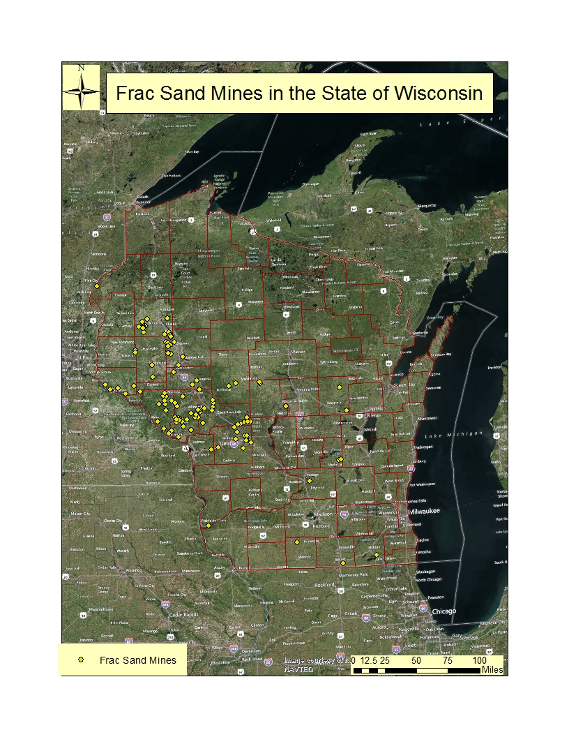
Once each person had their points correctly geocoded on the map, the four feature classes had to be merged and combined into one, so that all the points were correctly represented. Once this was done, the locations of all the sand mines were able to be mapped together, as shown in Figure 2. Now that this task was complete, network analysis can be done in the future to determine the effects of transporting the sand from the mines to railroads to be distributed to the fracking operations.


Figure 2: Locations of sand mining facilities in the state of Wisconsin. Each yellow dot represents a mine.

Thursday, March 14, 2013

Overview of Frac Sand Mining in Wisconsin

Overview of Frac Sand Mining and Wisconsin's Importance


Frac sand mining is the process of extracting frac sand from the ground, and using that sand in the process of fracking, or hydraulic fracturing, to access oil and natural gas mines that are trapped under and between rock formations. The frac sand needs to be of a certain size and shape, well-rounded and uniformly round, and composed of nearly pure quartz. The sand is put into fluids and then placed into these oil and natural gas mines at very high pressure, causing the rock to split open. The fluid is removed, and the resources can be extracted.
Recently, there has been a push to start using the sand found in Wisconsin for hydraulic fracturing.
The mined sand will be used for sand fracturing. The sand in Wisconsin is of the perfect size and shape to be used in the fracking process, making the state's resources extremely valuable to the future of the United States to become energy independent. The perfect sand can be found in the sandstone in western and central Wisconsin. Figure 1 shows a map of the frac sand distribution around the state of Wisconsin, and initial mine locations as of December 2011.
Figure 1: Frac Sand Locations in Wisconsin
The sand present in the southern and eastern parts of the state are not suitable for sand fracking, because the grains are not as consistently round and the composition is not comprised of pure quartz, which is absolutely essential to the fracking process. The sand in the western and central parts of the state has been less exposed to the elements, and makes it closer to the forms needed to be used in the extraction of oil and natural gas in other parts of the country.


Issues Surrounding Frac Sand Mining in Wisconsin

There is no doubt that mining frac sands in the state of Wisconsin will be a tremendous economic opportunity. The miners make a great wage, due to the sand's sale to energy companies, who are flush with cash from the high price of oil and natural gas. These workers in turn take that money and spend it within the state, providing an increase in tax revenue for the state, allowing for surplus funds that could be used for tax breaks, education programs, or investment in infrastructure that can benefit the entire state. Economic benefits aside, some serious concerns have been raised on the harmful effects of frac sand mining on the environment and, through these adverse effects, on the health of workers in the mines and the residents of the state living near the mines. The speed of setting up these mines, and the aggressive promoting of the economic benefits have overshadowed the lack of research into sand frac mining, or the impacts on the environment, which have caused some people to raise questions as to whether this industry is truly good for the state in the long run.

The safety of the miners is one large concern of advocates for not increasing sand mine operations in the state. Breathing in the silica dust from the sand can cause logical health problems, like aggravating respiratory diseases like asthma. But there are other, more serious, diseases that could develop years after unprotected exposure to the dust, like cancer and silicosis, which is a lung disorder that has typically affected miners and construction workers. The Occupational Safety and Health Administration has recently released a report investigating silica dust levels at the mining sites, with almost a third of the sites having more than ten times the recommended amount present. But most of these companies require their workers to wear protective breathing apparatus during times when they are exposed to mining dust, which reduces the risk of contracting these kinds of chronic diseases.

One thing that has not been examined extensively is the impact of the sand mine dust on the general public, outside of the proximity of the mine itself. Crispin Pierce, an environmental health expert at the University of Wisconsin-Eau Claire, has said that while any silica dust can be harmful if the particles are small enough to slip past the body's defenses, the freshly fractured crystalline silica from mining and processing operations is thought to be particularly damaging. One grain of silica sand is comprised of many crystalline silica particles. Fractured free by industrial blasting or crushing, these particles are sharp, chemically reactive and, according to Pierce, have been shown to cause more lung inflammation in animals than the kind of weathered silica likely to be kicked up from a farm field or dirt road. Despite the potential risk of silica dust, the Environmental Protection Agency has only classified as particulate matter, lessening the amount of regulation required of it. Additionally, mining companies need to have a plan for controlling this dust that is created at any stage of the mining, storage, or transportation processes.

Other concerns of frac sand mining include increased carbon emissions from the machinery doing the mining, and the trucks that are transporting the sand to the nearest railroads, which is typically how the sand is moved out of state to the hydraulic fracking sites. Processing chemicals at the plants where the sand is transported has also been suspected of polluting groundwater in the area, which, if confirmed, can have far-reaching health effects. These carbon and chemical pollution issues are the primary concerns for people outside of the mining profession, as it spreads the risk to people who are not directly associated with the mine, significantly expanding the potential number of people negatively affected by sand frac mining. In addition to these health-related issues, infrastructure degradation also can take place. The increase heavy machinery traffic in the areas where sand frac mining is prevalent wears down the roads quicker, requiring them to be repaved sooner than normal.

How can GIS be used to explore these issues involving sand frac mining?

Geographic Information Systems, or GIS, is a powerful tool that can be used to investigate the spatial relationships between objects in the real world. One such tool is a process called geocoding, which matches a table of addresses to their spatial position on a map. This information obtained from this can be used to identify the distribution of mines across the state. Also, geocoded points of mine positions can be used in network analysis, to determine which roads will be affected by the increase in traffic from heavy machinery and trucks transporting the sand from the mine to either processing plants or railroads. Additionally, environmental impact surveys can be conducted, to see if there is any damage on cropland and soil content in the area due to the frac sand mining. By using GIS to solve these tasks, a more thorough analysis of the impact of the sand mining on the environment can be done to provide either confirmation or absence of the suspected impact they will have on the state.

References